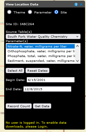
Site Specific Search
The Site Specific Search tool allows users to examine individual research sites and the measurement
data collected at the site. For the selected site and table, the user may examine, graph, and download
one, many, or all parameters collected. The Site Specific Search tool is only available at the
watershed location level of the interface.
To use the Site Specific Search tool:
- If you are not at a watershed location, choose a watershed from the Select Research Location list.
-
The MapTips need to be turned off. To do this, check Map Tips box on the Select Research Location
tool to turn the tips off
 .
This will remove the Map Tips icons
.
This will remove the Map Tips icons  from the map
and allow a site to be selected.
from the map
and allow a site to be selected.
- Click on a site location on the map. The 'X' near the symbol(s) will activate a site in the Site Specific Search toolbar.
- Select a Source Table from the list then a Parameter(s).
- The Record Count button can be used to display the number of records returned from your selection.
- The Begin Date and End Date can be modified to limit the search to a particular date range.
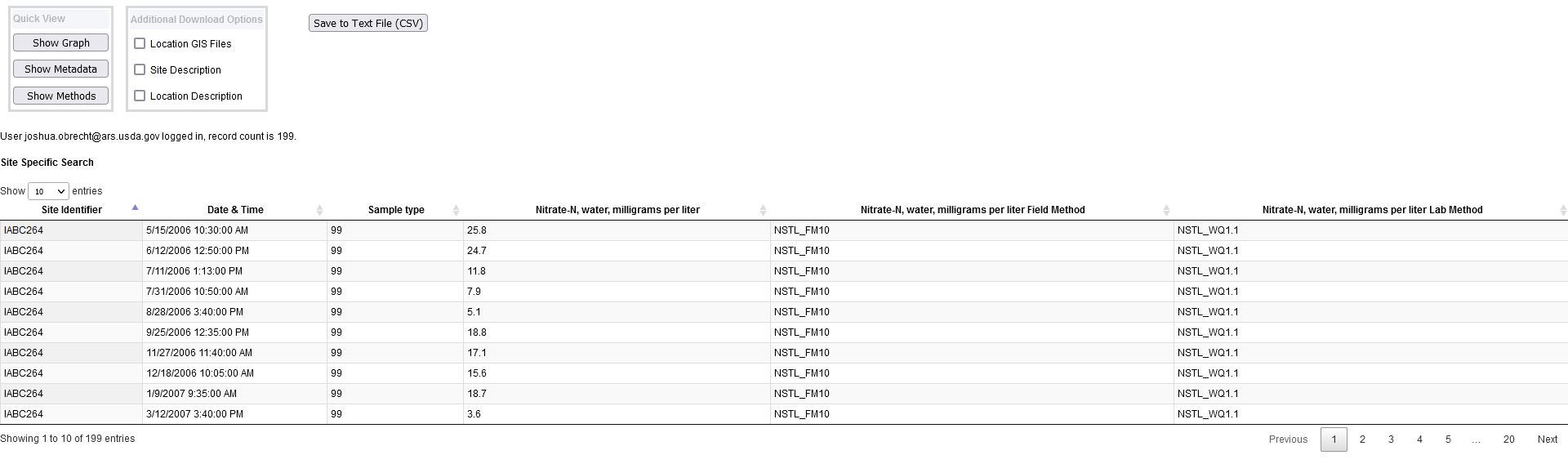
Site Specific Query Results
Performing a Site Specific Query by choosing Get Data will generate a
results window similar to the one shown below. There are several options that the user may choose:
- Choosing the Show Graph button produces a graph of the data over the date range
- Choosing Show Metadata displays an HTML version of the metadata associated with the data, and
- Choosing the Show Methods button brings up a PDF file of the methods used to produce these data
The Save To ...buttons are not available unless logged in. See login help for
new users or existing users for more information.
To download data, choose either the Save to Excel or Save to TextFile buttons.
-
The Save to Excel choice will generate a standard MS Excel format file with the data on one worksheet
and descriptive information on a separate worksheet. There is a 64,000 record limit to the size of an Excel
spreadsheet. If the record count of the query exceeds the limitation, this choice will not be available.
-
The Save to TextFile choice will generate a ASCII textfile in a comma-separated (csv) file.
The csv-format file is compatible with most database management software.
Descriptive information on a separate textfile.
The user has the option to download ancillary data associated with these files. Choose from one or more of the
Additional Download Options and the information will be downloaded to the users computer.
- Choose the Location GIS Files to download the watershed location's spatial data in an ESRI file geodatabase format
- Choose Site Description to download a pdf format version of the site's description file
- Choose Location Description to download the location's description file
Clicking on the hyperlinked Site Identifier in the main body of the data display generates a description of the site.
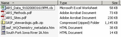
Final Data Output
The output data will be made available in an archive or compressed (.zip) format. At a minimum the archive will contain:
- The data (Excel or csv-format text)
- Download description information
- on an Excel download, the description information is on a separate worksheet
- on a text file download, the description information is in a separate file
- Research methods (ARS_methods.pdf)
- The FGDC Metadata in HTML format
Additionally, choices are available to download a watershed description, a site description report, and
the watershed GIS data. An example excel download archive listing is shown below.